Canada’s newly announced plan to invest 1 billion Canadian dollars ($739 million) over the next 15 years in the Radarsat mission is part of the federal government’s climate resilience strategy. The Radarsat satellite series has been a pivotal component of Canada’s climate change strategy and international disaster response. It holds an even greater significance at a time when the country is grappling with unprecedented extreme weather events, all symptomatic of a changing climate.
Canada’s escalating warming rate, at twice the global average and over three times faster in its northern regions, as flagged by the federal government in 2019, makes the urgency of climate action even more apparent. These changes are no longer mere forecasts; they are now glaring realities that affect different parts of the nation, calling for immediate attention. According to Catastrophe Indices and Quantification Inc., 2022 ranked as the third worst year for insured losses in the country’s history, while the total insured damages from severe weather events across the nation amounted to CA$ 3.1 billion in the past year.
In the face of this, Canada has adopted an aggressive climate strategy, reaffirming its commitment to lower emissions and combat climate change, introducing new programs, and fine-tuning its path to achieve net-zero emissions by 2050.
Satellite-based Earth observation is clearly a crucial tool in the government’s efforts to generate solutions for climate change mitigation and adaptation. The strategy for Earth observation, called Resourceful, Resilient, Ready: Canada’s Strategy for Satellite Earth Observation and unveiled in 2022, included an investment of CA$8 million in grants for 21 organizations across the country to advance innovative applications in Earth observation for sustainable development.
Now, the hefty investment towards the Radarsat+ initiative, as announced Oct. 18 by Minister of Innovation, Science, and Industry Francois-Philippe Champagne in a live-streamed address delivered at the Space Canada annual industry conference in Ottawa, is focused on ensuring steady access to “crucial and high-quality Earth observation data”. The goal is simple: bolstering Canada’s resilience in the face of climate change and stepping up the capacity to respond to increasingly severe natural disasters.
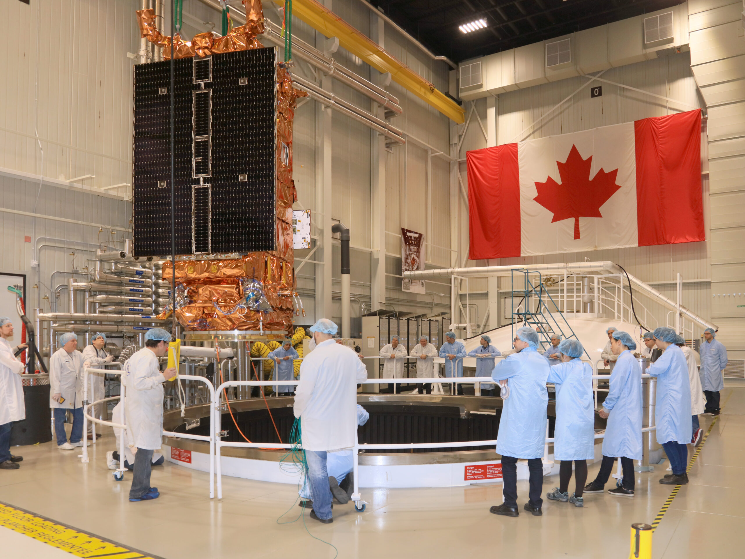
Radarsat+ encompasses various projects, as Champagne explained, including the design, construction, and launch of a replacement satellite for the Radarsat Constellation Mission (RCM), as well as the initiation of a fourth-generation national sovereign satellite system to succeed the RCM. The mission will be a collaboration between the Canadian Space Agency (CSA) and the Canadian space industry.
Minister of Environment and Climate Change Steven Guilbeault also emphasized in a statement, “high-quality satellite data is crucial to Canada meeting its environmental goals.”
As the effects of climate change and global warming accelerate, there is an increasing demand for timely and reliable Earth observation data, particularly with the rise in extreme weather events and natural disasters.
In May, the government unveiled the National Risk Profile, Canada’s first-ever public, strategic national-level assessment of disaster risks. It provides a comprehensive national view of disaster risks, current emergency management resources, and measures in place to mitigate them. It is a crucial piece in the national Emergency Management Strategy, which outlines priorities to enhance emergency preparedness and reduce disaster risks. Satellite data is key to making science-based decisions — from climate change adaptation to building resilience in vulnerable areas such as Canada’s North.
As Champagne highlighted, “increasing the capability for satellite Earth observation means fostering a safer, more predictable environment in Canada”.
Radarsat data is already part of Canada’s contributions to the 17-agency International Disasters Charter, which deploys satellite information in response to global crises, underscoring the significance of high-quality satellite data.
Radarsat+ will further empower Environment and Climate Change Canada to track sea ice patterns and monitor critical ecosystem health across the vast Canadian landscape.
Continuing the legacy
Canada’s commitment to the Radarsat program has deep roots, with the launch of the first Radarsat satellite in 1995 marking the beginning of the nation’s reputation as a global leader in radar satellite Earth observation. With the enhanced capabilities offered by Radarsat+, Canada is poised to maintain and strengthen this legacy.
Radarsat data is highly regarded and widely used by government stakeholders, including the Canadian military, civil and environmental officials, as well as international space agencies such as NASA and the European Space Agency.
The fresh infusion of funding in the Radarsat+ program, now with an enhanced annual budget of approximately CA$67 million, significantly enhances Earth observation capabilities beyond CSA’s average annual of about CA$500 million for all programs.
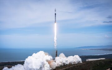
With the current Radarsat satellites aging, the new funding will serve a dual purpose. Firstly, Radarsat+ will introduce a fourth satellite to complement the three existing ones in the Radarsat Constellation Mission (RCM), which was developed by MDA and launched in 2019 and is expected to operate until 2026 without intervention. The addition of the fourth satellite will extend the timeline of the constellation.
Additionally, the program will finance the definition phase of a successor mission, which Champagne described as a “fourth-generation national sovereign satellite system,” set to launch in the 2030s. This mission’s manufacturing and launch will require further funding in the upcoming years.
Key role in Arctic strategy
The Radarsat series also plays a central role in Canada’s Arctic strategy, where maritime monitoring is a significant challenge. The satellites complement other monitoring methods, such as aircraft and ships.
However, it is crucial to note that “radar imagery satellites are at — or will reach — the end of their expected service lives long before the planned launch dates of the replacement satellites,” as was highlighted in a report by Auditor General Karen Hogan last year. The report also stressed the pressing need for new satellites due to “incomplete surveillance and insufficient data about vessel traffic in Canada’s Arctic waters.” The delay in renewing maritime monitoring infrastructure has reached a point where some assets may retire before replacements are available.
Originally projected for a 2035 launch, the new satellite’s readiness has become all the more imperative.
- SEO Powered Content & PR Distribution. Get Amplified Today.
- PlatoData.Network Vertical Generative Ai. Empower Yourself. Access Here.
- PlatoAiStream. Web3 Intelligence. Knowledge Amplified. Access Here.
- PlatoESG. Carbon, CleanTech, Energy, Environment, Solar, Waste Management. Access Here.
- PlatoHealth. Biotech and Clinical Trials Intelligence. Access Here.
- Source: https://spacenews.com/canadas-budget-boost-for-radarsat-is-part-of-its-climate-strategy/
- :has
- :is
- :where
- $UP
- 1
- 15 years
- 15%
- 1995
- 2019
- 2022
- 2026
- 2050
- a
- About
- accelerate
- access
- According
- Achieve
- across
- Action
- adaptation
- addition
- address
- adopted
- advance
- affect
- agencies
- agency
- Aging
- aircraft
- All
- already
- also
- an
- and
- announced
- annual
- apparent
- applications
- approximately
- arctic
- ARE
- areas
- AS
- assessment
- Assets
- At
- attention
- available
- average
- BE
- become
- been
- before
- Beginning
- between
- Beyond
- Billion
- bolstering
- boost
- budget
- Building
- by
- calling
- Canada
- Canadian
- capabilities
- capability
- Capacity
- central
- challenge
- Champagne
- change
- Changes
- changing
- civil
- clearly
- Climate
- climate action
- Climate change
- collaboration
- combat
- commitment
- Complement
- component
- comprehensive
- Conference
- construction
- contributions
- country
- country’s
- crises
- critical
- crucial
- Current
- data
- Dates
- decisions
- deep
- definition
- delay
- delivered
- Demand
- deploys
- described
- Design
- developed
- Development
- different
- disaster
- disasters
- due
- earth
- ecosystem
- effects
- efforts
- emergency
- Emissions
- emphasized
- empower
- encompasses
- end
- enhance
- enhanced
- Enhances
- ensuring
- Environment
- environmental
- European
- European Space Agency
- Even
- events
- existing
- expected
- explained
- extend
- extreme
- Face
- faster
- Federal
- finance
- First
- first-ever
- firstly
- flagged
- focused
- For
- forecasts
- fostering
- Fourth
- fresh
- from
- funding
- further
- General
- generate
- Global
- global warming
- goal
- Goals
- Government
- grants
- grappling
- greater
- Health
- high-quality
- Highlighted
- highly
- history
- holds
- HTML
- HTTPS
- IBC
- ICE
- immediate
- imperative
- in
- included
- Including
- increasing
- increasingly
- Indices
- industry
- information
- Infrastructure
- infusion
- Initiative
- Innovation
- innovative
- International
- intervention
- introduce
- introducing
- Invest
- investment
- IT
- ITS
- jpg
- karen
- Key
- landscape
- Last
- Last Year
- launch
- launched
- leader
- Legacy
- Lives
- Long
- longer
- losses
- lower
- maintain
- MAKES
- Making
- management
- manufacturing
- Maritime
- marking
- May..
- means
- measures
- meeting
- mere
- methods
- Military
- million
- minister
- Mission
- Mitigate
- mitigation
- Monitor
- monitoring
- more
- Nasa
- nation
- National
- Nations
- Natural
- Need
- net-zero
- New
- New Funding
- newly
- Newswire
- next
- no
- North
- note
- now
- observation
- Oct
- of
- offered
- officials
- on
- ones
- operate
- or
- organizations
- Other
- Ottawa
- outlines
- over
- part
- particularly
- parts
- past
- path
- patterns
- phase
- piece
- pivotal
- Place
- plan
- planned
- plato
- Plato Data Intelligence
- PlatoData
- plays
- Point
- poised
- Predictable
- pressing
- Program
- Programs
- projected
- projects
- provides
- public
- purpose
- quantification
- radar
- ranked
- Rate
- reach
- reached
- Readiness
- ready
- reaffirming
- realities
- reduce
- regarded
- regions
- reliable
- replacement
- report
- reputation
- require
- resilience
- resilient
- resourceful
- Resources
- Respond
- response
- Rise
- Risk
- risks
- Role
- roots
- s
- safer
- satellite
- satellites
- Science
- SEA
- Series
- serve
- service
- set
- severe
- ships
- significance
- significant
- significantly
- Simple
- Solutions
- some
- sovereign
- Space
- space industry
- stakeholders
- Statement
- steady
- stepping
- steven
- Strategic
- Strategy
- Strengthen
- succeed
- such
- surveillance
- sustainable
- Sustainable Development
- system
- that
- The
- their
- Them
- There.
- These
- they
- Third
- this
- three
- time
- timeline
- timely
- times
- to
- tool
- Total
- towards
- track
- traffic
- Twice
- unprecedented
- until
- unveiled
- upcoming
- urgency
- used
- various
- Vast
- Vessel
- View
- Vulnerable
- was
- Waters
- Weather
- WELL
- when
- which
- while
- widely
- will
- with
- without
- Worst
- year
- years
- zephyrnet