Sign up for daily news updates from CleanTechnica on email. Or follow us on Google News!
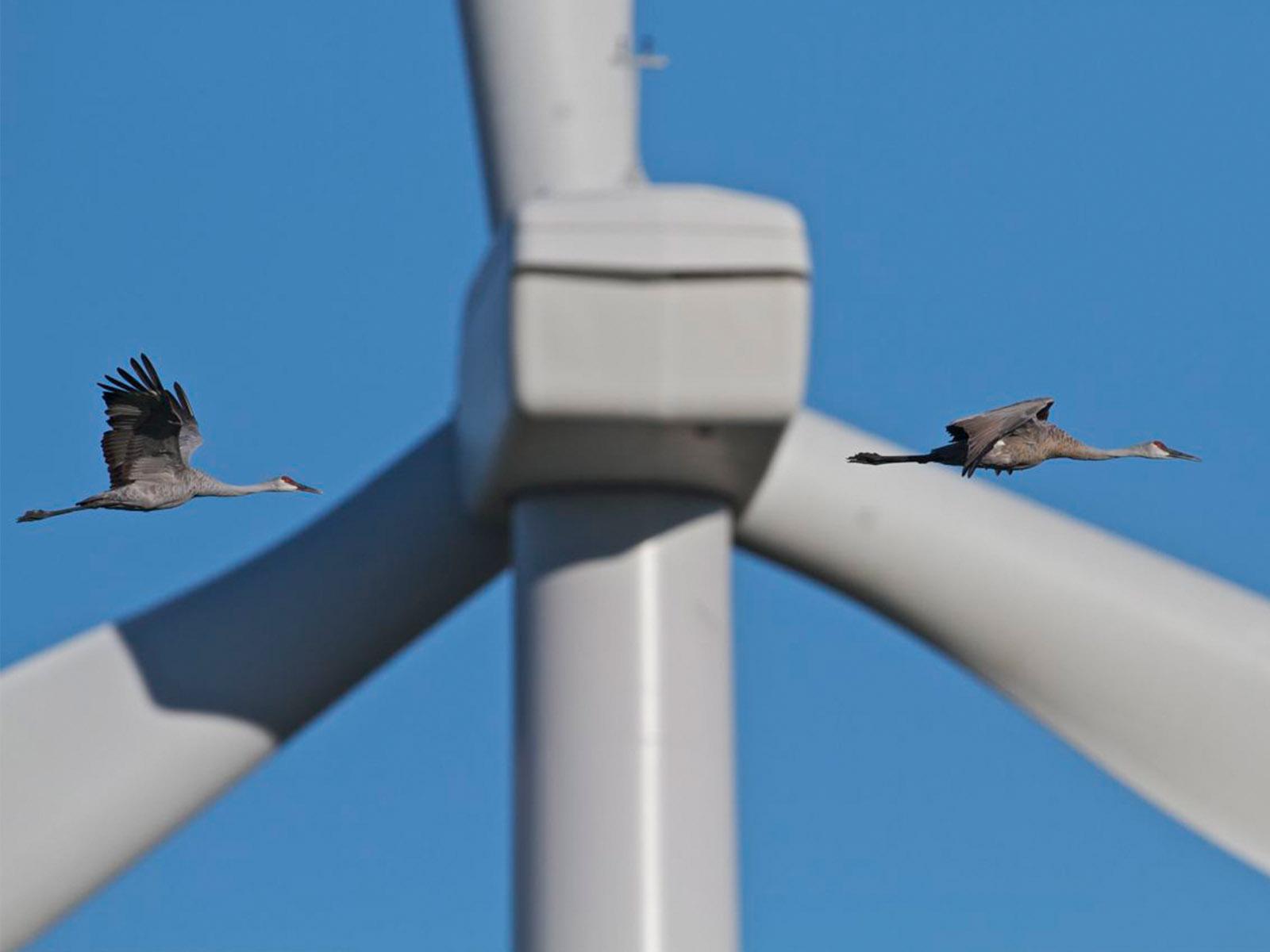
Tracking how high West Coast seabirds fly will help researchers understand environmental impacts from offshore wind
One day, wind turbines may float off the coasts of California and southern Oregon, providing clean, renewable energy to millions of homes. But before construction can start, researchers are studying how to minimize the potential wind farms’ impact on local wildlife.
Researchers from the Department of Energy’s (DOE’s) Pacific Northwest National Laboratory (PNNL) and environmental consulting firm H. T. Harvey & Associates recently deployed technology off the West Coast in one of the first efforts to understand how high seabirds fly and whether they might interact with wind turbines and other infrastructure. They published the research on April 24 in Frontiers in Marine Energy.
“This is an important step in understanding seabird behavior at the height of offshore wind turbines on the West Coast,” said Shari Matzner, computer scientist at PNNL and coauthor on the paper. Data from scientists on research vessels have provided estimates of how high birds fly, depending on wind strength, but “this is really the first time we’ve had real-time, quantified flight height data for these birds,” Matzner said.
Tracking birds
Scientists have studied impacts of wind turbines in Europe and on the East Coast, which have a more mature offshore wind industry. Previous studies have found very low rates of collisions between birds and offshore wind turbines. But deep waters off the West Coast host a much different community of seabirds than both those places, said Scott Terrill, paper coauthor and principal senior avian expert at H. T. Harvey. Out there, birds like albatross, shearwater, and petrels hunt for food and depend on the same strong winds that make these waters ideal for generating power.
These birds spend much of their lives in the air. To stay aloft using the least amount of energy, the birds hitch rides on strong gusts of wind to gain altitude and then coast downwards in a flight pattern known as “dynamic soaring.” Researchers want to know whether dynamic soaring—and other flight behavior—might bring these birds to the height of offshore wind turbine blades, which would stretch from 25–260 meters (82–853 feet) above the water.
“Certain kinds of seabirds actually need wind for effective, or even any, flight. They have long, narrow wings like glider aircraft. It’s important to quantify the degree to which seabirds and offshore wind turbines might overlap,” Terrill said.
During the summer of 2021, DOE and PNNL, along with the Bureau of Ocean Energy Management, launched a buoy fitted with PNNL’s ThermalTracker-3D (TT3D), a stereo camera system that uses a pair of thermal cameras to track birds as they fly overhead. Researchers have already used TT3D on land to monitor birds as well as bats as they navigate around land-based wind turbines, but this is the first time the technology has been deployed at sea. After deployment, the H. T. Harvey team evaluated the bird flight data.
Bobbing on a buoy around 40 kilometers (25 miles) off the northern Californian coast, TT3D monitored the sky for nearly 2,000 hours over the summer of 2021. The instrument spotted more than 1400 birds flying both day and night. Out of the 1400 birds tracked, 79% of them flew in the first 25 meters (82 feet) above sea level, with most activity concentrated in the first 10 meters (33 feet) above sea level—far below hypothetical turbine blades. Of the remaining birds tracked, 21% flew at heights that overlapped with hypothetical turbine blades, while fewer than one percent flew higher. No birds were tracked flying higher than 316 meters (1036 feet) above sea level (the detection range of the system is limited to around 400 meters, or 1312 feet). Where the day length was about 14 hours, most birds were spotted during the day, but TT3D also tracked activity at dawn, dusk, and overnight.
“These data add to the baseline understanding of bird behavior and will help us better understand how any future wind turbines may affect seabirds,” said Matzner, who led the development of TT3D at PNNL.
Protecting from environmental impacts
The latest work adds to a bulk of research from PNNL that aims to minimize the impact of renewable energy projects on wildlife.
To complement data from TT3D, PNNL researchers are also working on a system that uses radar to track bird flight at sea. While TT3D can generate details about flight patterns and provide some data to help researchers identify species, it doesn’t “see” long distance. Radar, on the other hand, doesn’t offer fine detail, but its detection range would allow for tracking the behavior of a population of birds around places intended for wind turbines, Matzner said.
This year, TT3D will also be deployed to study birds on the East Coast, as a part of the Wind Forecast Improvement Project, a PNNL-led project to improve weather forecasts for utilities.
The Frontiers study won’t be the last of its kind on the West Coast, Matzner said. Although TT3D can spot birds, the ability to tell what species they are is still a work in progress. Researchers also need to understand how birds might be affected aside from collision risk; some studies show that bird populations will completely avoid areas with wind farms, for example. More data will be needed to fully understand how birds use the air they may one day share with wind turbines.
The work presented in the Frontiers study was funded by DOE’s Wind Energy Technologies Office. To address remaining research questions, TT3D has received additional funding through DOE’s Wind Energy Technologies Office and the California Energy Commission to design, build, and test a new TT3D system to collect bird and bat activity data off the West Coast. This next-generation system will help researchers identify birds and bats at the species level.
H. T. Harvey & Associates, ecological consultants, was founded in California in 1970. It has more than 80 specialized ecologists, landscape architects, and other professionals in four offices in California and one in Hawaii. Its multidisciplined offshore marine energy team is led by Sharon Kramer, principal and senior marine ecologist, from the firm’s Humboldt County, California office.
Study contributors included lead author Stephanie R. Schneider, Sharon H. Kramer, Sophie B. Bernstein, Scott B. Terrill, and David G. Ainley from H. T. Harvey, and Shari Matzner from PNNL.
By JoAnna Wendel, PNNL. Featured image by Microsoft Copilot.
Have a tip for CleanTechnica? Want to advertise? Want to suggest a guest for our CleanTech Talk podcast? Contact us here.
Latest CleanTechnica.TV Videos
[embedded content]
[embedded content]

Advertisement
CleanTechnica uses affiliate links. See our policy here.
- SEO Powered Content & PR Distribution. Get Amplified Today.
- PlatoData.Network Vertical Generative Ai. Empower Yourself. Access Here.
- PlatoAiStream. Web3 Intelligence. Knowledge Amplified. Access Here.
- PlatoESG. Carbon, CleanTech, Energy, Environment, Solar, Waste Management. Access Here.
- PlatoHealth. Biotech and Clinical Trials Intelligence. Access Here.
- Source: https://cleantechnica.com/2024/05/23/seabird-study-shows-how-they-might-one-day-share-the-air-with-offshore-wind-turbines/
- :has
- :is
- :where
- $UP
- 000
- 10
- 14
- 2%
- 2021
- 2024
- 24
- 25
- 33
- 40
- 400
- 80
- a
- ability
- About
- above
- activity
- actually
- add
- Additional
- address
- Adds
- Advertise
- affect
- affected
- Affiliate
- After
- aims
- AIR
- aircraft
- allow
- along
- already
- also
- Although
- amount
- an
- and
- any
- April
- architects
- ARE
- areas
- around
- AS
- aside
- associates
- At
- author
- avoid
- b
- Baseline
- BAT
- bats
- BE
- been
- before
- behavior
- below
- Better
- between
- bird
- Birds
- both
- bring
- build
- bulk
- Bureau
- but
- by
- california
- camera
- cameras
- CAN
- clean
- cleantech
- Cleantech Talk
- Coast
- collect
- collision
- commission
- community
- Complement
- completely
- computer
- Concentrated
- construction
- consultants
- consulting
- content
- contributors
- copilot
- county
- data
- David
- day
- deep
- Degree
- Department
- depend
- Depending
- deployed
- deployment
- Design
- designing
- detail
- details
- detect
- Detection
- Development
- different
- distance
- DOE
- Doesn’t
- during
- Dusk
- dynamic
- East
- east coast
- Ecological
- Effective
- efforts
- embedded
- energy
- energy projects
- environmental
- estimates
- Ether (ETH)
- Europe
- evaluated
- Even
- example
- expert
- Farms
- Feet
- fewer
- fine
- First
- first time
- flight
- Float
- flying
- food
- For
- Forecast
- forecasts
- found
- Founded
- four
- from
- Frontiers
- fully
- funded
- funding
- future
- Gain
- generate
- generating
- Guest
- had
- hand
- Have
- hawaii
- height
- heights
- help
- High
- higher
- Homes
- host
- HOURS
- How
- How High
- How To
- HTTPS
- hunt
- ideal
- identify
- image
- Impact
- Impacts
- important
- improvement
- in
- included
- industry
- Infrastructure
- instrument
- intended
- interact
- IT
- ITS
- jpg
- kilometers
- Kind
- kinds
- Know
- known
- laboratory
- Land
- landscape
- Last
- latest
- lead
- least
- Led
- Length
- Level
- like
- Limited
- links
- Lives
- local
- Long
- Low
- low rates
- make
- management
- Marine
- mature
- max-width
- May..
- Microsoft
- might
- millions
- minimize
- Monitor
- monitored
- more
- most
- much
- narrow
- National
- Navigate
- Near
- nearly
- Need
- needed
- New
- news
- next-generation
- night
- no
- node
- ocean
- of
- off
- offer
- Office
- offices
- Offshore Wind Turbines
- on
- ONE
- open
- or
- Oregon
- Other
- our
- out
- over
- overhead
- overlap
- overnight
- Pacific
- pair
- Paper
- part
- Pattern
- patterns
- percent
- photo
- Places
- plato
- Plato Data Intelligence
- PlatoData
- player
- podcast
- policy
- population
- populations
- potential
- power
- presented
- previous
- Principal
- professionals
- Progress
- project
- projects
- provide
- provided
- providing
- published
- quantified
- Questions
- R
- radar
- range
- Rates
- real-time
- really
- received
- recently
- remaining
- Renewable
- renewable energy
- research
- researchers
- rides
- Risk
- Said
- same
- Scientist
- scientists
- scott
- SEA
- Sea level
- see
- senior
- Share
- show
- Shows
- sky
- soaring
- some
- Southern
- specialized
- spend
- Spot
- start
- stay
- Step
- Still
- strength
- stretch
- strong
- studied
- studies
- Study
- Studying
- suggest
- summer
- system
- T
- Talk
- team
- Technologies
- Technology
- tell
- test
- than
- that
- The
- The West
- their
- Them
- then
- There.
- thermal
- These
- they
- this
- those
- Through
- time
- tip
- to
- track
- tracked
- Tracking
- turbine
- tv
- understand
- understanding
- Updates
- us
- use
- used
- uses
- using
- very
- vessels
- Video
- want
- was
- Water
- Waters
- Weather
- WELL
- were
- West
- What
- whether
- which
- while
- WHO
- Wildlife
- will
- wind
- wind energy
- wind farms
- wind turbine
- winds
- wings
- with
- Work
- working
- would
- year
- youtube
- zephyrnet